Australia's already variable climate may be particularly susceptible to a punishing sequence of events. This starts with reduced rainfall sourced off the nation's north-west,combining with a strong El Nino in the Pacific to intensify drought over the food bowl regions of south-eastern Australia,only to be followed by floods during a powerful La Nina event the following year.
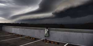
Cleopatra Moir watches as shelf cloud rolls into Sydney.Nick Moir
That extreme and rare trifecta - similar to the combination that occurred during 1997-99 - will happen about once every 48 years compared with about once every 187 years in the past, inNature Climate Change says. The research is based on more than 20 climate models.
But even weaker versions of the three elements are likely to have an amplified impact as background warming from climate change makes rainfall shifts and heatwave conditions easier to generate.

A warming planet is likely to make extreme events such as intense El Ninos at least twice as common.Lindy Percival
"In the future,what you're more likely to see in terms of[temperature changes],it doesn't have to be so big as to generate as big an impact"as the most powerful El Ninos or La Nina today,said Wenju Cai,a CSIRO principal research scientist and lead author of the paperEverything becomes more energetic.
The current El Nino in the Pacific has already been,with its rapid warming of the sea-surface temperatures in the central and eastern Pacific in line with that monster event.
El Ninos are marked by a stalling or reversal of the eastern trade winds that blow along the equatorial Pacific. One result is that rainfall typically drops well below average in places such as Indonesia while nations to the east such as Peru get hard hit by flooding.
The impact of El Ninos in Australia typically hinges on whether the influence from the Pacific is compounded by changes in the Indian Ocean.
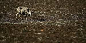
More intense droughts and flooding rains are in prospect as the planet warms up.Ian Waldie
A so-called positive Indian Ocean Dipole (IOD),when temperatures in the east of that ocean tend to be relatively cool compared with those in the west,is usually negative news for Australian farmers in the country's south-east. Those cooler conditions mean less rain and cloud cover streaming across.
Extreme positive-IODs now occur about once every 16-17 years,a frequency that will rise to about once every six or seven years over the course of this century,Dr Cai said.
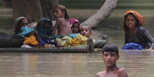
Villagers wade through floodwaters in Rajanpur,Pakistan last month.Asim Tanveer
Axel Timmermann,a professor of oceanography at the University of Hawaii and another of the paper's authors,said the research is consistent with work he published on increased sensitivity to extremes in the climate back in 1999.
Even as the models become fine tuned in their projections of worsening future outcomes,they can still struggle to predict just when an El Nino,for instance,will get going.
"We have the event right in front of us that the El Nino community was pretty much expecting for last year,"Professor Timmermann said.
Major agencies predicted an El Nino in 2014 when strong westerly wind bursts were detected from January to April. However,the ocean circulation changes needed to reinforce the processes didn't happen and so the event died.
Professor Timmermann said that weather observations are more vital in predicting the onset,while climate models do a better job in determining the intensity and duration of an El Nino once it is under way.
Michael McPhaden,a senior scientist at the US National Oceanic and Atmospheric Administration,noted inon Tuesday that understanding why an El Nino happened this year and not in 2014 will provide fertile ground for researchers.
What is well understood,though,is that climate change will likely produce more extreme conditions.
"The same sea-surface anomaly on a warmer background state will lead to a stronger atmospheric response,"Dr McPhaden said.
"Because the precipitation will be more intense over the central and eastern equatorial Pacific over the ocean,the droughts,say in Australia,could be more intense."