The Richmond Bridge on Bells Line of Road was closed as the Hawkesbury River swelled,with the bureau warning the river could reach major flood level on Friday night and peak at 11.5 metres. The Lower Nepean River may also reach major flood level.
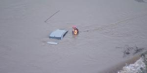
Helicopter footage shows an SES volunteer checking a car that was almost entirely submerged on the Menangle Bridge.Nine News
The NSW State Emergency Service (SES) told residents in part of Lower Portland,east of the Hawkesbury River,to evacuate before 2am on Sunday. The river may reach the minor flooding level at Sackville and the area may be affected by dangerous floodwaters,the SES said in a warning issued on Friday night.
People in Camden and Menangle,south-west of Sydney,and at Chipping Norton in the city’s west,were also warned to prepare to flee rising waters,the SES said.
Those who remained may find themselves trapped without power,water and other essential services and it may be too dangerous to rescue them,the SES warned.
Heavy rain across the Sydney basin,the South Coast,Illawarra and the Southern Tablelands over the past 48 hours has flooded roads,damaged houses and prompted dozens of rescues.
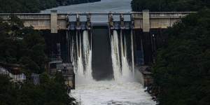
The Warragamba Dam started spilling at 4.20am.Nick Moir
Residents in low-lying areas of the Nepean River were warned at 4.20am on Friday that Warragamba Dam had begun to spill.
It is the third consecutive month the dam has spilled. The dam supplies 80 per cent of Sydney’s drinking water and releasing water to reduce storage levels and mitigate flooding ahead of predicted rainfall is not permitted.
It came as the catchment received 87mm of rain in 48 hours.
In Sydney,62 millimetres of rain was recorded at Observatory Hill in the 24 hours to 9am on Friday,but the highest falls were further south near Wollongong. More than 200 millimetres was recorded at Port Kembla.

The SES had issued 43 flood warnings as of 5pm on Friday,including eight telling residents to prepare to evacuate or isolate along the Hawkesbury and Nepean rivers.
SES crews have responded to more than 700 incidents over the past three days,including 474 in the 24 hours to 4pm – two-thirds of which were on the South Coast and in the Illawarra.
Spokesman Ben Deacon said there had been 39 rescues in the 24 hours to 4pm on Friday,mostly for people trapped in cars in floodwaters. A family in Warrawong,south of Wollongong,had to be rescued from the second storey of their home just before midnight after their first floor flooded and they watched their shed float away.
He said the SES was focusing on riverine flooding rather than flash-flooding.
“We’re playing very close attention to the Hawkesbury-Nepean valley. We have a series of flood warnings at different places along the river,” he said.
“A handful of properties,historical properties that were built beneath the one-in-a-100 flood line ... may be flooded,but no widespread impacts are expected.”
The bureau said the Nepean River at Penrith could reach about 6.2 metres on Friday evening,and the Hawkesbury may reach seven metres at Windsor overnight and into Saturday.
Moderate flooding was occurring on Friday along the Upper Nepean River,forcing the closure of the Menangle Bridge and prompting one motorist to abandon their car after it became trapped on a bridge.

Debris piles up against the Cowpasture Bridge at Camden as the Nepean River rises.Kate Geraghty
Helicopter footage showed a NSW State Emergency Service volunteer checking the vehicle,which was almost entirely submerged.
The Yarramundi and Cattai bridges were also closed in the Hawkesbury-Nepean areas. South of Sydney,the Illawarra Highway was closed at Albion Park. Meanwhile,the Princes Highway south of Jervis Bay reopened after flooding closed the road in both directions. Other local roads across the state were closed due to flooding.
A spokesman for the Transport Management Centre warned people leaving Sydney for the long weekend to drive to conditions,which could change quickly,and to never drive into floodwaters. Motorists should also check for road closures on the Live Traffic app.
A severe weather warning issued by the Bureau of Meteorology advised heavy rain will continue in the Illawarra region and the south coast of NSW on Friday afternoon,as rain eases around Sydney.
As much as 100mm could fall in six hours in some areas,while others have already copped a drenching,the bureau warned.
Angus Hines,a senior meteorologist at the bureau,said the low pressure systems in the south-east of Australia were set to move away and take the rain with them on Saturday.
“Over the past couple of days some places around southern Sydney and in the Illawarra have seen 200 to 300mm,about two months’ worth of rainfall in less than three days,” he said.
“Because we did see that heavy rain,there are still likely to be some flood warnings in play as these river levels are running really high at the moment on the back of that rainfall.”
With AAP
Get to the heart of what’s happening with climate change and the environment.